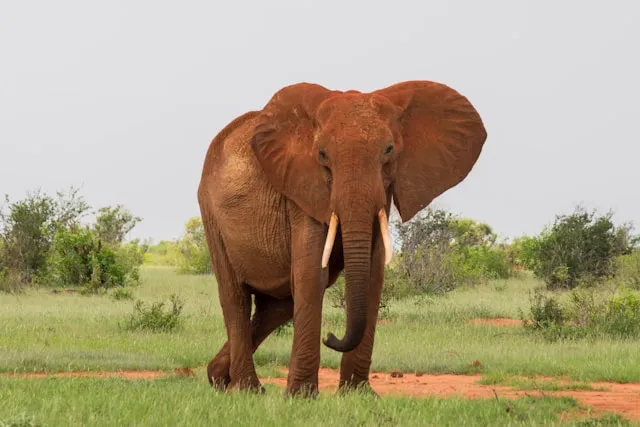
Tsavo East is the largest national park in Kenya and, in many ways, the opposite of the Masai Mara. Where the Mara is small, dense, and busy, Tsavo East is vast, sparser, and quiet. The wildlife concentration is lower per square kilometre, but the number of vehicles per sighting is far lower too — you can spend a morning here barely seeing another car. The park is famous for its dust-red elephants, the Galana River corridor, and the Yatta Plateau (the world's longest lava flow). If your idea of a safari is big country and few people rather than guaranteed high-density action, this is the page for you.
Tsavo East covers around 13,700 km2, roughly nine times the size of the Masai Mara Reserve. That scale changes what a trip here looks like. You spend more time covering ground; sightings are less frequent but more memorable for the lack of other vehicles; and you need to plan distances deliberately, because crossing the park takes hours, not minutes. The southern third of the park (south of the Galana River) is the developed self-drive area with the lodges, most game tracks, and the main attractions; the northern two thirds are wilder, less visited, and generally requires permission and more substantial preparation.
Wildlife highlights: the famous red elephants (the local soil is iron-rich and dust-coats the elephants when they roll in it), large lion populations, leopard, cheetah, buffalo, and reintroduced black and white rhino. The Galana River draws hippo and crocodile concentrations and is the spine of the southern park. Be honest with yourself: density is lower than the Mara or the Serengeti, so come for the wilderness feel and the photographic oddity of the red dust, not for guaranteed Big Five in a morning.
Tsavo East is unusually well-positioned: it sits along the main Nairobi–Mombasa highway (A109), with multiple gates spread across its long southern boundary. This makes it a rare park you can equally well visit from Nairobi (about 5–6 hours by tarred road) or from Mombasa (3–4 hours), and a natural fit for any cross-Kenya itinerary combining the safari with coastal time.
Voi Gate (south) — the main and
most-used entry, near Voi town on the A109. Closest to KWS
headquarters and the lodge cluster (Voi Safari Lodge,
Sentrim, Voi Wildlife Lodge). The natural choice for most
self-drivers from either Nairobi or Mombasa.
Manyani Gate (south-west) — the other
primary highway gate, useful if heading toward the
Mtito Andei area or combining with Tsavo West.
Bachuma Gate (south-east) — the
natural entry from Mombasa via the coastal road.
Sala Gate (east, toward Malindi) —
used by visitors approaching from the north coast; the
route from Malindi to Sala is a known and feasible
self-drive itinerary on its own.
Mtito Andei Gate (north) — primarily
used for Tsavo West, but accessible to Tsavo East via the
connecting park road.
Tsavo East rewards route planning more than the smaller Kenyan parks. The southern developed area has three anchoring landmarks — the Galana River corridor, Aruba Dam, and Mudanda Rock — and most good itineraries connect at least two of them.
The classic introduction. From Voi Gate, head north-east toward Aruba Dam — one of the park's most reliable water sources and a constant draw for elephant, buffalo, and the predators that follow them. From Aruba, swing north-west to Mudanda Rock, a 1.5-km outcrop overlooking a watering hole where leaving the vehicle is permitted for a viewpoint walk. Around 80–100 km round trip, ideal for a first full day.
The Galana River cuts through the southern park east to west and is the spine of any longer Tsavo East trip. Drive the river tracks from the Galana Crossing area upstream to Lugard Falls (a series of rapids and water-carved rock formations where you can leave the vehicle) and back. High game density on the river, hippo and crocodile concentrations in the pools. Allow a full day, ideally with an early-morning start.
If you are doing a Kenya self-drive that combines the coast and a safari, entering at Sala from Malindi and crossing the southern park to exit at Voi makes the park the route rather than a detour. Around 110 km inside the park, all game-viewing terrain, full day allowed. Works just as well in reverse.
Better than the deeper Botswana parks, worse than Amboseli or the Mara. Of the Kenyan carriers, Safaricom has the strongest coverage and is what most lodges and guides use. Signal is reasonable around Voi town, at the main lodges, and near the A109 boundary; it drops in the central park along the Galana, becomes non-existent in the wilder northern sectors. Live navigation apps that stream maps will simply stop working in those stretches.
The technical point most travellers miss: your phone's GPS works without any signal or data. GPS is a one-way satellite signal your phone receives directly. The only thing that fails offline is the map — so the maps have to be stored on the device before you enter the park. This is precisely the gap SavannaQuest is built for: every Tsavo East map is pre-loaded, so positioning and route recording keep working with the phone in airplane mode — particularly important here given the size of the park.
KWS provides a paper map at the gates with the official circuits marked. Take one and carry it alongside any app. Given the park's size, a printed overview of the southern section is genuinely useful for planning days around distances, water sources, and gate-closure times. Treat a navigation app as a "where am I, how far to camp" companion, not a replacement.
The dry seasons (June–October and January–February) are the strongest for both game viewing and driving conditions. The two rainy seasons (March–May and November) bring storms that wash out the rougher tracks, especially in the north, and the park can close some sectors entirely. Tsavo gets very hot — this is one of the warmest of the major parks, especially in February — so plan dawn and late- afternoon drives and rest mid-day.
Can you self-drive in Tsavo East?
Yes — the southern park is well set up for self-drive and far quieter than the Mara. The northern two thirds are wilder and need more preparation. A 4x4 is mandatory.
Do you need a 4x4 in Tsavo East?
Yes. Tracks are rough and sandy; the Galana area in particular needs a proper 4x4. Most rental operators provide Land Cruisers or Prados.
Which gate should I use?
Voi Gate for most self-drives (main entry, on the A109). Bachuma from Mombasa, Sala from Malindi, Manyani as an alternative highway entry.
Is there phone signal in Tsavo East?
Patchy. Safaricom near gates and lodges, drops in the interior, non-existent in the north. GPS positioning still works without signal if your maps are downloaded in advance.